Rattlesnake Wilderness Trip Report
|
Trip Report AT A GLANCE:
Route: Day 1: Rattlesnake Trailhead to Franklin Bridge, 8.2 miles Day 2: Franklin Bridge to Little Lake, 10 miles Day 3: Little Lake to Sanders Lake, Day 4: Sanders Lake to Glacier Lake, Day 5: Glacier Lake to Big Lake, Day 6: Big Lake to Upper Twin Lakes, Day 7: Upper Twin Lakes to Rattlesnake Trailhead, |
Stats: Total Mileage: Elevation Gain: Elevation Loss: Big Game Sightings: 0 (deer, snakes, black squirrels, chipmunks, ducks, bald eagles) |
The following tip report details our 7 day, 6 night backpacking loop through the Rattlesnake Wilderness just outside of Missoula, Montana.
Day 1 -- Rattlesnake Trailhead to Franklin Bridge, 8.2 miles
We parked our truck at the Rattlesnake Trailhead. There was no permit needed and restroom facilities were located just past the parking lot. We began by taking the Main Rattlesnake Corridor Trail #515. During this section, the trail resembled a highway more than a trail; it's wide, flat and straight--along the way we encountered many joggers, walkers and mountain bikers. Insert Pic 03022 At .4 mi there is a trail junction on the left with Spring Gulch Trail #517 and again at .6 with Spring Gulch Trail #517.1; this is the junction where we looped back to finish our trip on day 7. We continued along trail 515 and at mile 2.5 encountered Poe Meadows. At this point trail 515 splits, but it meets back up with itself so feel free to go either way. Along the southern route (515.1) there are three nice little campsites with easy water access along the Rattlesnake Creek. One is particularly big and open and would make a great campsite for introducing children to backpacking (there are bathroom facilities along the northern route, so no need to dig a hole here). From Poe Meadows to Franklin Bridge there are three creek crossings all with bridges, so no need to worry about water. You should, however, watch for mountain bikers--pedestrian traffic is almost non-existent past Poe Meadows, but bikers are plentiful. Poe Meadows to Franklin bridge is another easy 5.1 miles with very little elevation gain.
Franklin Bridge has one campsite, so get there early if you are determined to stay (however, there is ample space to accommodate multiple groups and numerous tents). The campsite is large and flat, has very easy water access, a fire ring, and a bear pole. Good firewood can be found along the trail just past the bridge. The creek is pretty loud and fast moving.
Word to the wise--keep all your belongings in your tent; my buddy left his boots out overnight and awoke to discover that they had been chewed up pretty good.
Day 2 -- Franklin Bridge to Little Lake, 10 miles
Just past Franklin Bridge, the Main Rattlesnake Corridor Trail #515 intersects with trail #514; veer left to continue on trail #515. Slight elevation gain here but the views start to open up on the left so we were rewarded for our efforts. At Mile 2.6 trail 515 connects with the West Fork Gold Creek Trail #52, which is a much shorter mileage alternative to reach the high lakes of the Rattlesnake Wilderness than the Rattlesnake Trailhead is, although it does require a significantly longer drive to the trailhead from Missoula. Again veer left, continuing on trail #515. Interspersed along the way there are three established campsites all with fire rings right off the trail; I wouldn't recommend staying at any of them because I did not see any access to water, but they could be helpful if you notice a storm rolling in and want to set up shelter. Eventually the views become obscured by trees, but to compensate there is an abundance of huckleberries on both sides of the trail which makes a nice excuse to stop if you're interested. While we were snacking a ranger drove past (the trail is still wide enough to accommodate a truck at this point); she was on her way to post fire ban signs at the wilderness boundary. If you are running low on water there are two opportunities to filter along the way, one slightly before the junction with trail #504 and the other about a mile later close to the junction with trail #502 around mile 5.4. Veer left to follow trail #502. Just past the trail junction we came across another bridge at mile 5.8 near the wilderness boundary. Don't bother trying to filter water here; we stopped for lunch and wanted to filter water but the banks are quite steep and not worth the effort since there are much easier opportunities to access water before this point and again shortly after. At mile 6 we reached the wilderness boundary at the junction with trail #534. Taking trail #534 will take you towards Carter, Roosevelt, Worden and McKinley Lakes, but stay right and continue on trail #502. The trail changes noticeably here--while it still remains somewhat wide (for a short while), the vegetation becomes thicker and the trail eventually begins to resemble a wilderness trail. Continue approximately 4 miles along trail #502, which gradually becomes steeper and contains numerous switchbacks. We eventually came across the remains of a dilapidated historic cabin which signified we had reached Little Lake at 6,424 feet.
Little Lake is quite beautiful. While the scenery isn't as grand as Glacier National Park or the peaks as tall as those of the Mission Mountains, the Rattlesnakes are quite rugged, steep, and unique. The northeast side of Mosquito Peak looms 1,633 feet over Little Lake, and the lake itself is quite pleasant. Unfortunately, the two established campsites at Little Lake leave a bit to be desired--one is right next to the lake, very exposed with a great few but very rocky, and the other is small, in the trees and right next to the bear pole. Both have fire rings and offer easy access to water, particularly the one on the lake.
It began to rain as soon as we arrived, and as such we did not have time to set up our tents, so we spent the first hour or so sitting on our packs under some small trees. Eventually the rain subsided and we were able to set up camp, have a cocktail and cook dinner. We were without a fire but the full moon gave us quite a show. Both of us kept all our belongings in our tents this time around.
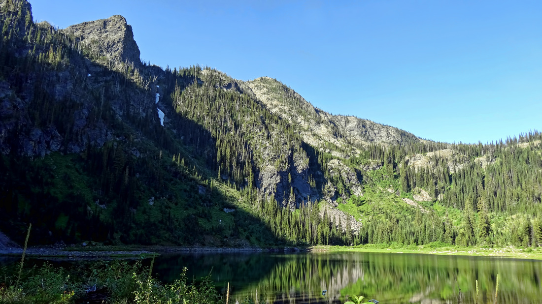
Little Lake in the morning
Day 3 -- Little Lake to Sanders Lake, 1 mile
The best part of this route in terms of scenery and overall short mileage began this day. Continuing on along trail #502 led us through a nice wooded area until we reached the junction with Trail #517 at mile 0.3. We took a right towards Sanders Lake and were immediately rewarded with views of Mosquito Peak that only got better as we gained elevation. The ground became rockier and the trees thinned out considerably, offering a multitude of places to stop and take pictures. Unfortunately for us, smoke coming from the Bitterroots made the light hazy and resulted in pictures with washed out skies. Around mile 0.6 we reached a saddle where, after a quick off-trail hike to a nearby high point, we were afforded great views of Sanders Lake and Murphy Peak in the distance (the highest point in the Rattlesnake Wilderness at 8,167 feet). From the saddle we descended approximately 200 feet until we reached the base of Sanders Lake at 6,885 feet. We did
We both viewed Sanders Lake as the highlight of the trip. The water was a clear, sparkling deep blue that rivaled any lake I have ever seen, including those of Glacier National Park. The scenery was not as grand, but from our campsite we had two fantastic views depending on which direction we looked--the first of Sanders Lake and the rising granite rock formation behind it, and the other
We saw at least two campsites at Sanders Lake, both of which had fire rings, and offered easy access to both water and the bear pole.
