Maps and Map Reading
If you're interested in backpacking, we're going to go out on a limb here and assume you've heard of a map. But for those of you that haven't, a map is a two-dimensional representation of an area of land or water that shows a variety of physical features through the use of special symbols and colors. If you're hiking or backpacking, however, you're going to want to get your hands on a topographic map, which is a type of map characterized by large-scale detail that uses markings called contour lines to represent the three-dimensional topography of the land. It's important to keep in mind that while topographic maps possess a vast amount of detail, lesser-known trails are not always included. As a result, it may be appropriate to pick up a local trail map to use in conjunction with your topographic map - the topographic map will supply you with accurate geographic information and a local trail map will provide details concerning trails, campsites, and other features.
Map Scale
The scale of a map is indicated in the map's legend, which is typically found along the margins of the map. The scale is represented by two numbers in a ratio - the first number is the map distance, which is always 1, and the second number is the ground distance. For example, a scale of 1:24,000 implies that 1 unit on the map is the equivalent of 20,000 of those same units in the real world (this could be in inches, feet, or meters, but the second number is generally converted to a more user-friendly distances such as miles or kilometers). In this circumstance, 1 inch on the map would be equal to approximately 2,000 feet (609meters), and 1 centimeter on the map (0.39 inches) would equal 240 meters (787feet). The link below provides a handy scale converter that could be helpful if you're still confused.
Cactus2000: Scale Converter
It's also important to understand that there are both small and large-scale maps. A larger scale 1:24,000 map will cover a smaller area and show smaller things such as individual buildings. On the other hand, a smaller scale 1:250,000 map will cover a larger area and show bigger things such as towns and cities. It's a little confusing since it seems contradictory, so just remember that the larger the second number in the ratio is, the smaller the scale of the map will be.
Finally, it's important to take the distance of your trip (i.e. the amount of area you plan to cover) into consideration when looking for an appropriate map. A typical USGS map used for hiking is the 1:24,000 scale (they are also referred to as 7.5 minute maps because they cover 7.5 minutes of longitude and latitude, which roughly translates to about 6.5 miles by 8.5 miles). These maps are usually suitable for the majority of backpacking trips, but if your plans include a month-long kayaking trip covering a much greater number of miles, you may want to consider using a smaller scale map that would depict less details and cover greater distances.
Map Colors and Symbols
USGS topographical maps use a variety of colors to depict different features:
http://egsc.usgs.gov/isb/pubs/booklets/symbols/
- White - an area with little or no vegetation; white with blue lines depicts permanent snowfields and glaciers
- Green - an area with substantial vegetation (including forest, scrub, etc)
- Blue - water (including lakes, rivers, and streams)
- Brown - contour lines that indicate elevation
- Black - man-made features (including roads, buildings, boundaries, etc)
- Red - major highways and public land area boundaries
http://egsc.usgs.gov/isb/pubs/booklets/symbols/
Map Legend
Each map contains specific information about the area that it covers. Below is a list of the major features of a map legend:
|
|
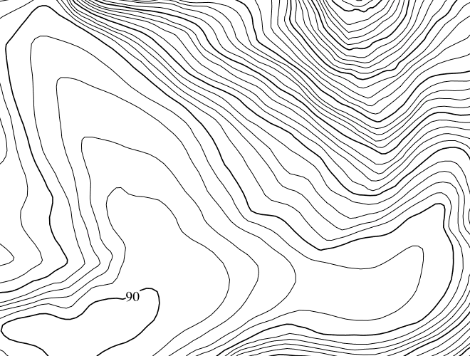
Contour Lines
|
Contour lines are lines on a map that join points of equal elevation above a given level (usually sea level) and which portray the three-dimensional character of the terrain on a two-dimensional surface. The change in elevation between each line is called the contour interval, and all points along the same contour line represent the same height above sea level.
As mentioned in the Map Colors and Symbols section, contour lines are represented in brown. The contour interval, or the distance (usually in feet) between each line, will be indicated in the map legend. When looking at contour lines, you'll notice that every fourth or fifth line looks darker than the rest, and that this line is labeled with a particular number. These are known as index lines. For example, a contour index line marked with the label 6,200 means that every point along that entire line is 6,200 feet above sea level. If the map legend says that the contour interval is 40, that means that the interval line to the inside of the index line would be 6,240 feet above sea level. Conversely, the interval line to the outside of the index line would indicate 6,160 feet. |
|
|
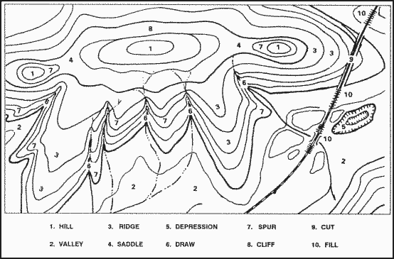
The image to the left demonstrates how contour lines can be utilized to identify a variety of surface features (click on the image for a larger image).
|
Maps and Map Reading Comments
Comments? Questions? Did we miss something? Can you explain something better? Advice to offer? All map and map reading comments here!
